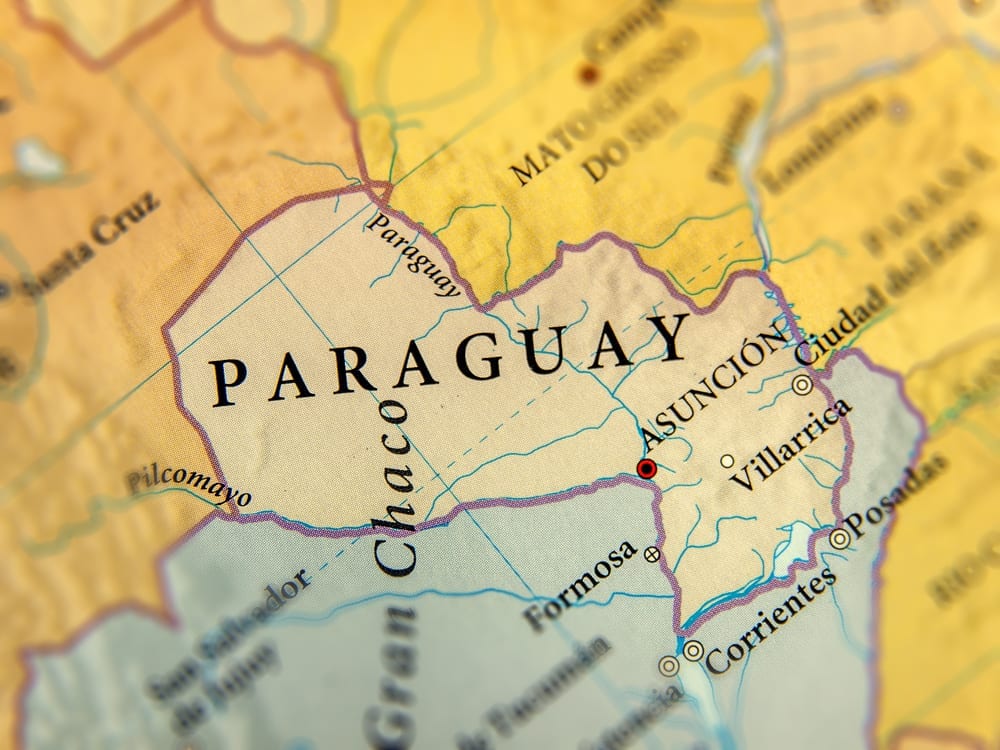
Abstract colour vector Map of Paraguay country
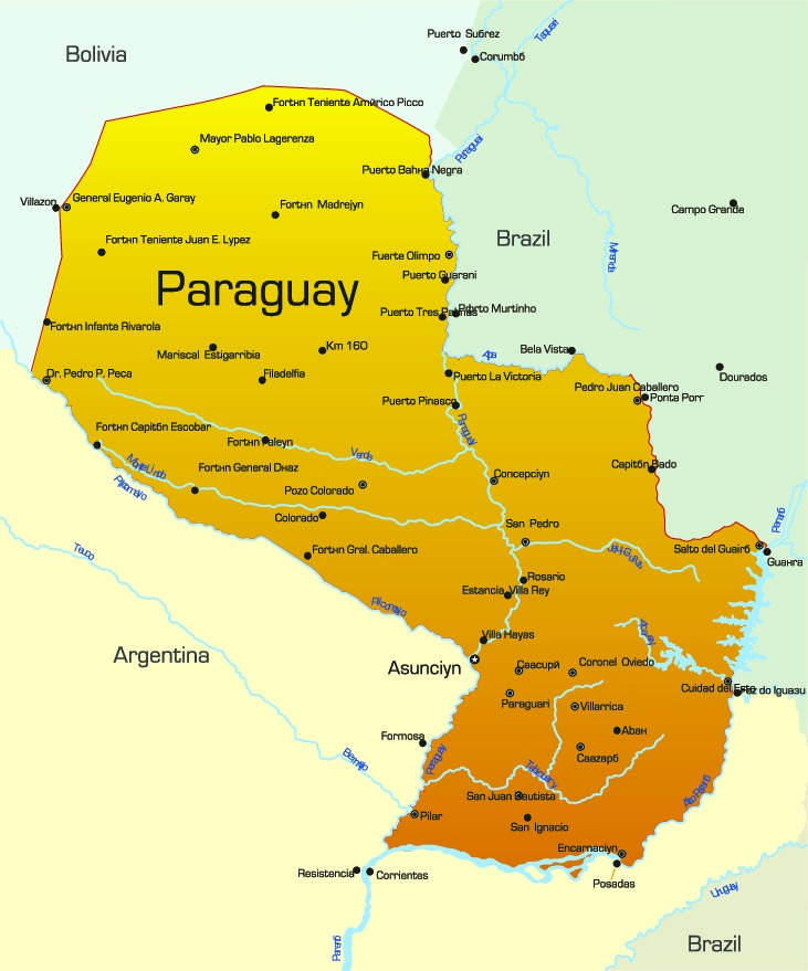
Administrative Map of Paraguay
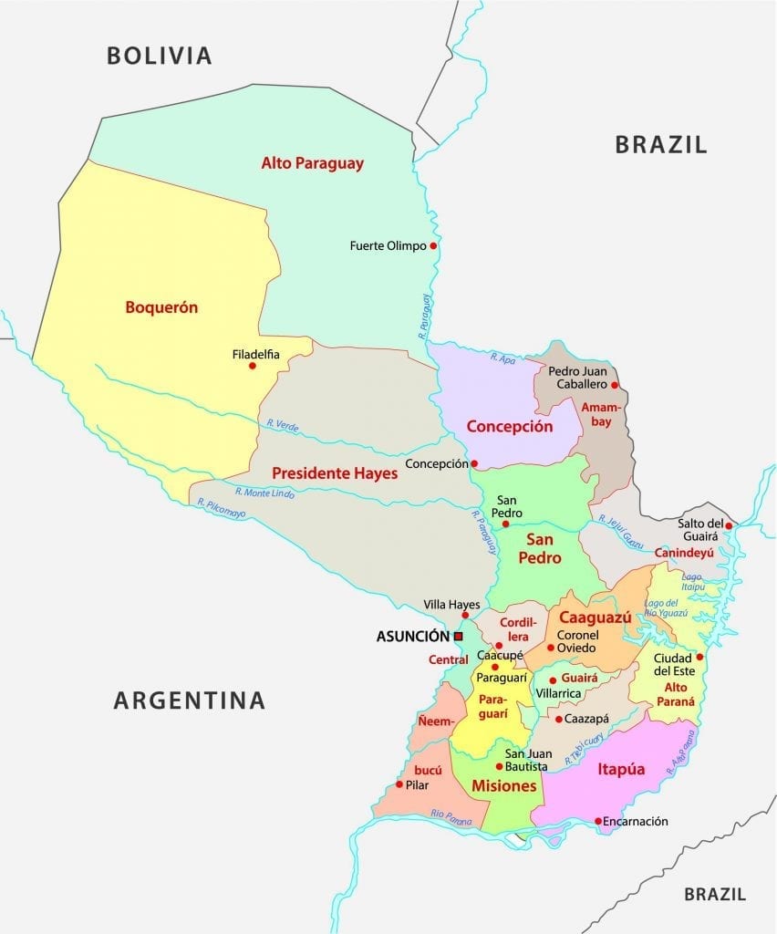
Map of Paraguay with the departments coloured in bright colours and the main cities
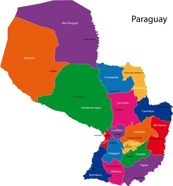
Map of Paraguay. Wire frame 3D mesh polygonal network line, design sphere, dot and structure. communications map of Paraguay. Vector Illustration EPS10.

Political Map of Paraguay
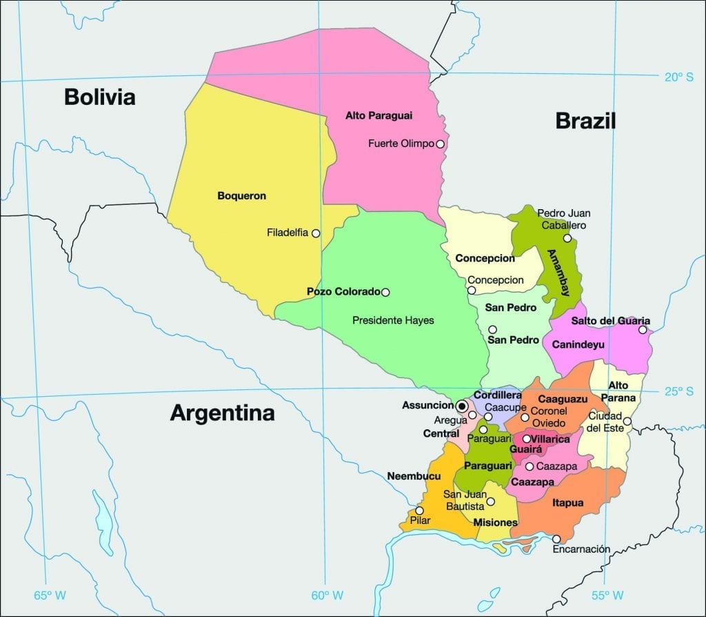
Paraguay is a country based in South America, hedged in by land on all sides. It is officially called the Republic of Paraguay (República del Paraguay). It is sometimes known as Corazón de Sudamérica (“Heart of South America”), as it is centrally located in South America. The area of Paraguay is around 4 million square kilometres and has a population of around 7.1 million people.
Paraguay has two official languages, which are Spanish and Guarani. This country obtained its name from the Paraguay River. In Guarani, ‘para’ means water, and ‘guay’ means birth. Therefore, Paraguay means ‘born of water.’ Nuestra Señora Santa María de la Asunción or more popularly known as Asunción is the capital and also the largest city in Paraguay. The official currency used here is called the Paraguayan Guaraní (PYG).
What is around Paraguay?
Paraguay shares its borders with three other South American countries. Bolivia lies to the northwest, Argentina lies to the south and southwest, and Brazil lies to the east and northeast.
The border between Argentina and Paraguay stretches for about 1,880 kilometres, while with Brazil, it shares a border of 1,290 kilometres. With Bolivia, it shares a border of 750 km.
Geography of Paraguay
Paraguay does not have a very diverse landscape. The Paraguay river runs across the middle of Paraguay, dividing the land into two distinct topographies. To the east lies the ‘Oriental Region’ and to the west lies the ‘Occidental Region,’ also known as the Chaco region; it forms a part of the Grand Chaco. Paraguay does not have many mountain ranges. The highest point in Paraguay is the Cerro Pero, which is 842 meters high.
Most of Paraguay’s population lies in the eastern part, which consists of the fertile Paraneña region. This area has beautiful grassy plains and thickly wooded trees. The famous Paraná plateau forms a part of the Paraneña region.
In comparison, the Chaco region is arid and has low marshes. The flatlands of the west are unsuitable for agriculture. The farthest north-western area is a desert.
Paraguay has three major rivers, namely, the Paraguay river, the Paraná river, and the Pilcomayo river. These rivers provide a source of hydro power and transportation in Paraguay. Paraguay has coasts, ports, and beaches on these rivers. The three rivers ultimately flow into the Atlantic Ocean, via other countries, and through the Paraná -Paraguay Waterway.
Climate of Paraguay
The climate of Paraguay ranges between tropical and subtropical. Paraguay mostly has wet and dry seasons. The lack of mountains allows winds to blow in from other land areas, sometimes at the speed of 161 km/hr. The months of April to September see temperatures dropping to sub-zero degrees because of the changing winds blowing in from the Andes.
Whereas in summer, the temperature rises as high as 29 degrees C with warm winds blowing in from the Amazon basin. Summer here is from October to March, with January being the hottest month.
The eastern region sees moderate to heavy rainfalls and is also prone to floods. The average annual rainfall received here is about 170 cm. The western region receives minimum to no rainfall making the Chaco region arid. The rainfall received here is approximately 50 cm per year.
History of Paraguay
Early History
Paraguay was inhabited by the Gurani tribe for the longest time. Almost a millennium later, the Spanish explorers landed on the shores of Paraguay in 1516. On August 15th, 1537, Juan de Salazar de Espinosa, a Spanish explorer, founded the first settlement of Asunción, which later became the capital city for the Spanish colonial province of Paraguay.
The spread of Christianity was undertaken by the Jesuits and the Spanish in the eighteenth century. Paraguay, however, overthrew the Spanish administration on May 14th, 1811. José Gaspar Rodríguez de Francia became the first dictator to rule over Paraguay from1814 until his death in 1840.
Rodríguez de Francia strived to reduce the power of the Catholic church and kept Paraguay cut-off from other South American countries. The lack of freedom created many independence-seeking leaders, but Francia managed to stay ahead of them every time.
After Francia’s death in 1840, various military leaders tried to stake claim to rule Paraguay, until Carlos Antonio López came to power in 1841. Carlos ruled until his death in 1862, after which his son Francisco Solano López became the President-Dictator of Paraguay. During their reign, the Lopezs’ opened Paraguay to trade and commerce and also strengthened its military power.
Paraguayan War (1864–1870)
In 1864, Brazil, Argentina, and Uruguay signed a Triple-Alliance Treaty to come together and fight the rising threat of Paraguay. Thus, began the Paraguayan War, which ended with Paraguay losing almost 1 million square kilometres of land to Brazil and Argentina. Paraguay also suffered a loss of 60-70% of its population, making it one of the most gruesome wars of South America.
Stroessner’s Rule 1954-1989
From 1904 to 1954, there was significant political instability in Paraguay, where leaders kept overthrowing each other by force. During this phase, Paraguay saw thirty-one presidents, the last of which was Alfredo Stroessner. His regime became the most prolonged Dictatorship regime in the history of Paraguay.
Alfredo Stroessner’s regime was overthrown in a military coup on February 3rd, 1989, making General Andrés Rodríguez the next Dictator of Paraguay. Rodriguez brought reforms in the country in 1993. It was the time when the first democratic elections were held in Paraguay.
Modern Day Paraguay
The current president of Paraguay, Mario Abdo Benítez, came to power on August 15th, 2018. Paraguay remains a third-world country.
Tourism in Paraguay
Paraguay is not the first name that springs up in the minds of travellers. It is one of the least visited countries in the world. However, Paraguay has a few beautiful places for explorers, as listed below.
- Saltos del Monday: This roaring waterfall is a spectacular sight on the outskirts of Ciudad del Este in Paraguay. Forty-five meters tall and 1120 meters wide, this thunderous waterfall is a must-visit.
- Itaipú Dam: Bordering with Brazil this is one of the world’s largest hydroelectric dam. An engineering marvel, this dam even has a beautiful mini-ecosystem flourishing around it.
- Ybycuí National Park: This incredible natural park is flourishing with flora and fauna. You’ll find this place in Asunción, the capital city. For those who want to take a walk with nature, this is an apt place.
- National Pantheon of the Heroes: As the name suggests, this is a tribute to the heroes of the many wars fought by Paraguay. It is a museum as well as a monument in the capital city.
Flag of Paraguay
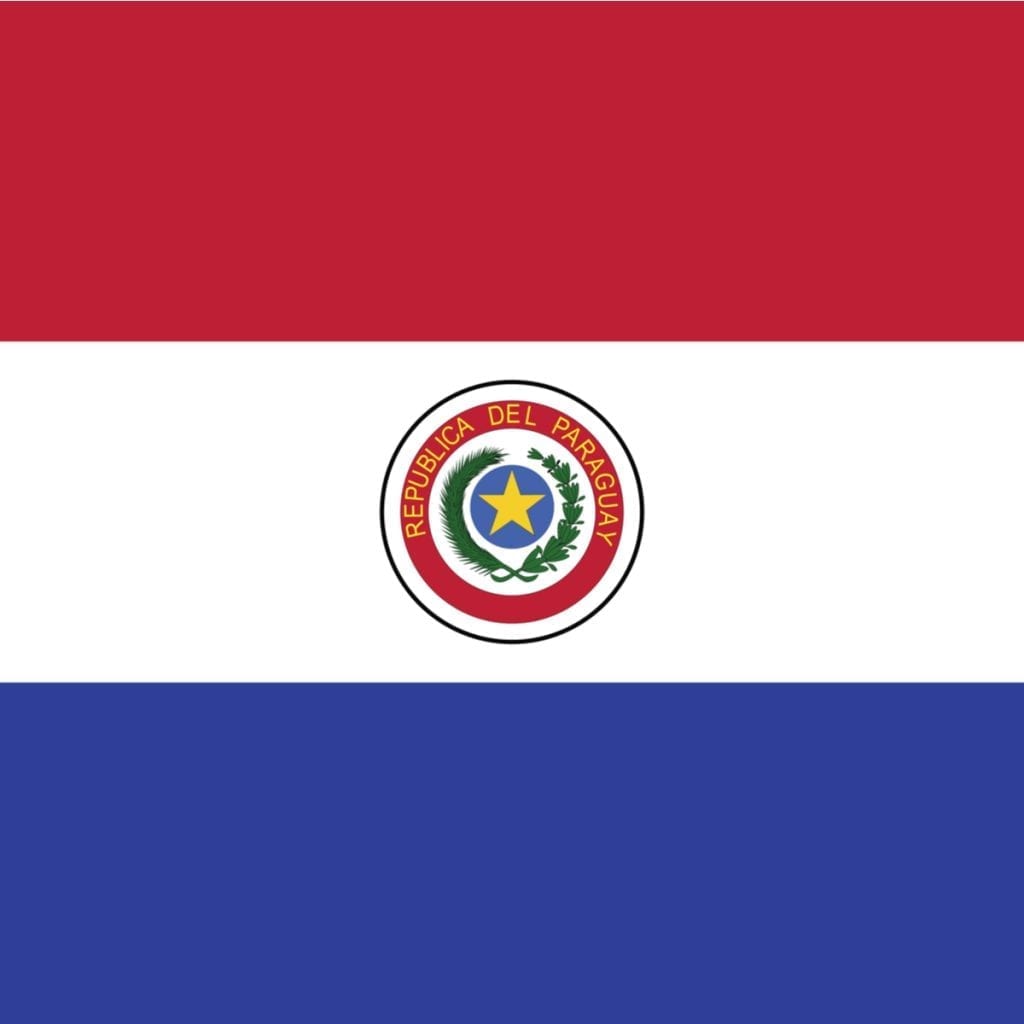
On both sides of the Paraguayan Flag are three equal bands of red, white, and blue. The white band on the front side has the Paraguayan coat of arms in the centre, while the reverse side has the emblem of the seal of the treasury. Paraguay is the only country in the world to have two different symbols on each side of its flag.
The colour of the flag was inspired by the French flag. The red stands for equality, courage, and patriotism, the white stands for peace, unity, and purity, and the blue stands for truth, benevolence, and liberty.
Fun Trivia about Paraguay
- Guarani Aquifer is the world’s largest drinking water reservoir underneath the soil in Paraguay.
- Paraguay is the fifth largest exporter of soybeans in the world.
- About 50% of the population here is bilingual and speaks both Spanish and Guarani.
- The Paraguay River is the 2nd longest river in South America. It covers a distance of 2,621 km and flows through Paraguay, Brazil, Argentina, and Bolivia.
- Duelling in Paraguay is a legal sport. However, only registered members can duel under medical supervision.
- Paraguay has a single border point with Argentina and Brazil.
- Between 1858 and 1861, the first railway line in South America was made in Paraguay. It was made by the British.
- Football and fishing are two of the most played sports in Paraguay.
- Paraguay’s population is approximately one-tenth of the UK, even though it is twice the size of the UK.
- The houses in Paraguay rarely have doorbells. You have to clap your hands instead.
Departments and Capital Cities of Paraguay
Capital – Asunción
- Concepción – Concepción
- San Pedro – San Pedro
- Cordillera – Caacupé
- Guairá – Villarrica
- Caaguazú – Coronel Oviedo
- Caazapá – Caazapá
- Itapúa – Encarnación
- Misiones – San Juan Bautista
- Paraguarí – Paraguarí
- Alto Paraná – Ciudad del Este
- Central – Areguá
- Ñeembucú – Pilar
- Amambay – Pedro Juan Caballero
- Canindeyú – Salto del Guairá
- Presidente Hayes – Villa Hayes
- Alto Paraguay – Fuerte Olimpo
- Boquerón – Filadelfia
Other Important Cities of Paraguay
Abai, Borja, Caaguazu, Caapucu, Capitan Bado, Capitan Pablo Lagerenza, Desmochado, Doctor Pedro P. Pena, General Eugerio A. Garay, Ita, Kilometro 160, Mariscal Estigarribia, Oviedo, Pozo Colorado, Puerto Bahia Negra, Puerto La Victoria, Puerto Pinasco, San Ignacio, San Lazaro, San Lorenzo, San Ygnacio, Tacuati, Villa Florida, and Villa Oliva.
BOOK ACCOMMODATION IN ANY PART OF PARAGUAY AT GREAT PRICES
See Also
Map and Flags of countries in South America
